On Naming

There’s a lot of variety in the fluffy white sheep milling about the fields throughout Britain. There are distinct breeds, and then there are the mules – crosses developed to match the best qualities from two or more breeds. Their names often tell you something about their origins – Border Leicesters, Lincoln Longwools, Kerry Hills, Herdwicks, Scotch Blackfaces, Suffolks, Romneys, Icelandics, and so on.
The local sheep is the Welsh Mountain, a functional name for a sheep that’s been bred to survive on poor land and with limited shelter. There are other Welsh sheep: the Lleyn, the Beulah,the Torddu and Torwen, the Black Welsh Mountain, and so on, but unlike some of the other, more well defined breeds, the Welsh Mountain seems to vary quite widely, from place to place, centred on the livestock markets. There are northern Welsh mountains (smaller, hardier), and then amongst the southern Welsh mountains there are more variants – Tregaron, Brecon, Llandovery. Our local variant is the Nelson. It’s notable for the brown nape of its neck, and is a bit bigger than most.

Nelson is a town south of Merthyr Tydfil, which still holds an annual ram sale. It also has an open-air handball court, which has apparently been there since the nineteenth century. Allegedly the town originally went by another, Welsh, name, but the large numbers of Irish and English workers who came together to play handball (or whatever game it was), gave up on trying to pronounce it, preferring to talk about the Lord Nelson pub, and so eventually the town’s name became the Nelson. And then the sheep.
On Places
I get intrigued by a set of tweets about the nineteenth century ‘tithe maps’, nineteenth century maps designed to establish who held what land and so owed what in taxes. I was aiming to look at the local library for them, but I discovered that the Welsh library has put them all online: https://places.library.wales/
It’s really interesting to see maps of the Welsh valleys before there were mines – lots of the towns that there are now barely exist.
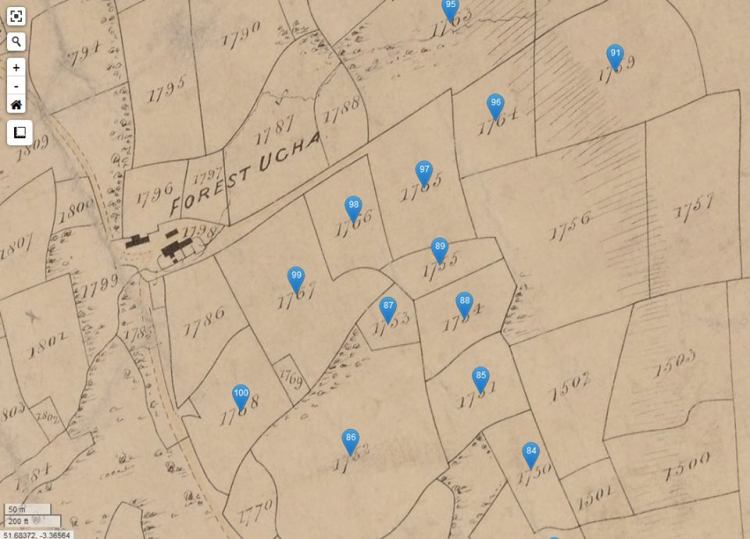
The original lure for the maps was that each of the fields are named, and I wanted to see if and what the name of our field was. So at first it was disappointing to discover that the maps are numbered. But it turns out that the blue tags include the name of the owner, the farmer, and the name of the field. Ours turns out to have the nice but generic name Waun (heath, moor?), but there are some more grand fields – Penrhew Caradoc is a particular local example. Also, and perhaps this is not surprising, all the field names are in Welsh.

Reblogged this on Zeelite.
LikeLike